


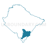
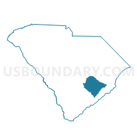
Cainhoy Voting District, Berkeley County, South Carolina
About
Outline

Summary
| Unique Area Identifier | 665196 |
| Name | Cainhoy Voting District |
| County | Berkeley County |
| State | South Carolina |
| Area (square miles) | 73.98 |
| Land Area (square miles) | 68.35 |
| Water Area (square miles) | 5.62 |
| % of Land Area | 92.40 |
| % of Water Area | 7.60 |
| Latitude of the Internal Point | 32.97748430 |
| Longtitude of the Internal Point | -79.85698550 |
Maps

Graphs
Select a template below for downloading or customizing gragh for Cainhoy Voting District, Berkeley County, South Carolina


Neighbors
Neighoring Voting District (by Name) Neighboring Voting District on the Map
- Christ Church Voting District, Charleston County, SC
- Cordesville Voting District, Berkeley County, SC
- Daniel Island No. 1 Voting District, Berkeley County, SC
- Daniel Island No. 2 Voting District, Berkeley County, SC
- Goose Creek No. 1 Voting District, Berkeley County, SC
- Huger Voting District, Berkeley County, SC
- Mt. Pleasant 32 Voting District, Charleston County, SC
- Mt. Pleasant 33 Voting District, Charleston County, SC
- North Charleston 9 Voting District, Charleston County, SC
- Pimlico Voting District, Berkeley County, SC
Top 10 Neighboring County Subdivision (by Population) Neighboring County Subdivision on the Map
- Goose Creek-Hanahan CCD, Berkeley County, SC (114,128)
- North Charleston CCD, Charleston County, SC (88,544)
- Mount Pleasant CCD, Charleston County, SC (78,960)
- Moncks Corner CCD, Berkeley County, SC (22,729)
- Wando CCD, Berkeley County, SC (12,942)
- McClellanville CCD, Charleston County, SC (4,913)
- Cordesville CCD, Berkeley County, SC (4,016)
Top 10 Neighboring Place (by Population) Neighboring Place on the Map
Top 10 Neighboring Unified School District (by Population) Neighboring Unified School District on the Map
Top 10 Neighboring State Legislative District Lower Chamber (by Population) Neighboring State Legislative District Lower Chamber on the Map
- State House District 99, SC (49,234)
- State House District 112, SC (45,649)
- State House District 108, SC (38,039)
- State House District 102, SC (37,248)
- State House District 110, SC (36,192)
- State House District 100, SC (34,763)
- State House District 113, SC (29,036)
Top 10 Neighboring State Legislative District Upper Chamber (by Population) Neighboring State Legislative District Upper Chamber on the Map
Top 10 Neighboring 111th Congressional District (by Population) Neighboring 111th Congressional District on the Map
Top 10 Neighboring Census Tract (by Population) Neighboring Census Tract on the Map
- Census Tract 46.08, Charleston County, SC (20,842)
- Census Tract 204.03, Berkeley County, SC (6,249)
- Census Tract 206, Berkeley County, SC (5,230)
- Census Tract 50, Charleston County, SC (4,913)
- Census Tract 34, Charleston County, SC (4,450)
- Census Tract 204.01, Berkeley County, SC (4,016)
- Census Tract 204.04, Berkeley County, SC (3,699)
- Census Tract 207.24, Berkeley County, SC (3,239)
- Census Tract 204.05, Berkeley County, SC (2,994)
- Census Tract 9801, Berkeley County, SC (0)
Top 10 Neighboring 5-Digit ZIP Code Tabulation Area (by Population) Neighboring 5-Digit ZIP Code Tabulation Area on the Map
- 29445, SC (53,588)
- 29461, SC (30,141)
- 29406, SC (29,314)
- 29466, SC (28,725)
- 29492, SC (10,262)
- 29450, SC (3,105)
- 29429, SC (2,737)
- 29434, SC (537)